Novaya Zemlya is an Arctic archipelago that consists of two main islands and a number of smaller ones located off the coast of northeastern Europe. Novaya Zemlya literally translates to “New Land”.
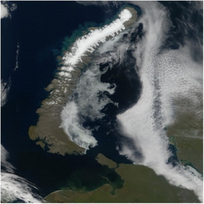
Novaya Zemlya Location
It lies between the Barents Sea and the Kara Sea, between 70°30′ and 77°N and 51°10′ and 70°E. The islands have a total area of 81,279 sq km (31,382 squares miles).
Administratively, they belong to Archangel (Arkhangelsk) oblast in the Russian Federation.
The two main islands are separated by the strait of Matochkin Shar – a narrow channel for the most part only 1–1.5 miles wide – while the Karskiye Vorota separates the archipelago from Vaigach Island to the southeast.
The west coast usually becomes accessible in midsummer as far north as Matochkin Strait and, less frequently, beyond. The east coast is much more difficult to approach, cut off from the comparatively warm waters of the Gulf Stream.
Novaya Zemlya is an extension of the Pai-Khoi hills, a branch of the northern Urals. The highest point is Sedova with 1,115 meters and it is located at the southern end of the northern island. Almost half of the northern island is covered with ice; the rest is bare – an Arctic desert. Arctic tundra covers the southern island. There are no trees or bushes. The islands contain deposits of copper, lead and zinc ores, pyrite, and asphaltite.
Average temperatures range from −22° C (−7.6° F) in January to 6.4° C (43.5° F) in July. Precipitation varies from approximately 152–229 mm (6 to 9 inches) annually. On the Map and Location page you can also see the Novaya Zemlya Sea surface temperature map.
Only the southern island is partly inhabited—by a small number of Samoyeds who engage in reindeer herding and trapping. Wildlife in the region include polar fox, polar bear, and lemming as well as a variety of birds, including seagulls.
Importance of Novaya Zemlya
Between 1955 and 1990, Novaya Zemlya was also the site of nuclear testing. Overall, 224 nuclear tests were conducted here.
In October 1961, the Tsar Bomba, the largest nuclear bomb was detonated in Novaya Zemlya. Novaya Zemlya has an important place in the history of polar aviation too.
The first successful flights anywhere in the Arctic were made by Jan Nagorski in 1914 during the search for Sedov’s missing expedition.
The first scientific station was opened at Maliye Karmakuly during the first International Polar Year (1882–1883), under the command of K. P. Andreyev, a Russian naval lieutenant.
The station was reopened in 1896 and has remained open ever since, being the longest-operating station in the Russian Arctic.
The Northern Scientific-Commercial Expedition of Rudolf Samoylovich began a program of systematic research in 1921. This was subsequently inherited by the Arctic Institute at Leningrad.
History of Novaya Zemlya
Novaya Zemlya was known to the Pomor inhabitants of the White Sea region of northern Russia from the early middle ages.
Novaya Zemlya Facts
In 1032, Uleb is said to have sailed as far east as the “Iron Gates,” the location of which is unclear, though possibly it is Kara Gate, which is sometimes referred to by this name. By the beginning of the 14th century, expeditions were regularly sponsored by the grand dukes of Moscow to obtain walrus tusks and hide, polar bear furs, salted geese, and other products.
By the middle of the 16th century, hunting voyages were organized on an annual basis, and encounters with Pomors are frequently referred to in the accounts of expeditions.
The first sighting by a Western European was made by Sir Hugh Willoughby in 1553, though the island was not actually reached until three years later by Stephen Borough, who reached the southern extremity of Novaya Zemlya in 1556.
The existence of Matochkin Strait was known to Western explorers and cartographers by the earliest years of the 17th century, as proved by its appearance on a map made by the Dutch merchant and diplomat Isaac Massa and published in 1612, where it is named “Matfeiof Yar.” Since it offered an alternative route into the Kara Sea, it would have been of the greatest interest to anyone seeking the Northeast Passage.
A letter concerning the activities of the English trader Anthony Marsh in the 1580s appears to suggest that by then the strait was known to the English. The letter refers to it as “Mattushan Yar,” a name most likely derived from “Matthews Land,” which was possibly the early name for Novaya Zemlya’s northern island.
Dutch navigator, William Barents, touched the southern island and followed its coast in 1594.
Novaya Zemlya Expeditions
While many expeditions reached the west coast, the east coast remained unvisited until a hunting and exploring expedition in 1760–176, led by Savva Loshkin cruised north from Kara Strait to spend two winters here, returning the third year along the west coast to complete the first circumnavigation.
In 1766, the hunter Yakov Chiratkin sailed through Matochkin Strait from west to east. This is the first documented transit, though probably not the first made by a hunter.
Sent to investigate Chiratkin’s report, the Russian naval officer Fedor Rozmyslov sailed through Matochkin Strait two years later and made the first accurate survey.
Several expeditions were dispatched in the early 19th century to improve charts of the coastline. Dense ice offshore and an outbreak of scurvy prevented Andrey Lazarev from accomplishing this in 1819.
Count Fyodor Litke was more successful between 1821 and 1824 on four voyages organized by the Russian Admiralty to investigate the potential of Matochkin Strait as a navigable route from European Russia to the Kara Sea and Siberia.
In addition to compiling the first accurate charts of this strait, Litke conducted a detailed survey of the west coast. Despite making several attempts, he was unable to reach the east coast.
Russian explorer Petr Pakhtusov charted the east coast for the first time in the 1830s, but his successors were unable to explore north of 74°24′N. This coastline was mapped for the first time by the members of Georgiy Sedov’s expedition in 1913 while wintering at Foka Bay.
Norwegian hunters began visiting Novaya Zemlya from 1869 onward. The walrus population of Svalbard was declining, and Erling Carlsen and Edvard Johanessen were persuaded to come here instead. Johanessen circumnavigated the island the following year, only the second time that this had been achieved. Hunters such as these regarded the islands as a no-man’s land rather than as part of Russia.
The Russian response was to relocate several Nentsy families to the settlement of Maliye Karmakuly in 1877. A relief station for shipwrecked sailors was also established here, consisting of a house, bathhouse, lookout post, and lifeboat. Sovereignty remained an issue well into the Soviet era, and Norwegian and other expeditions continued to visit until the islands were formally closed to non-Russians following the 1926 decree stating the Soviet Union’s claim to the sector between 32°4′35″E and 168°49′30″W.
After the Bolshevik Revolution, hydrographers and hydrologists were sent to work off the east coast. The passage of a small icebreaker, the Sibiryakov, around the northern tip in 1932 led to an inconclusive discussion of the possibility of developing a northern variant of the northern sea route.
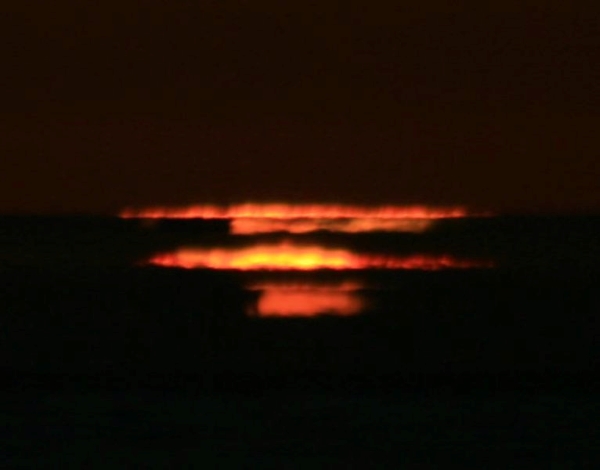
Novaya Zemlya Effect
The Novaya Zemlya effect is an arctic mirage named after the archipelago. The effect was first spotted in 1597, during the third polar expedition of William Barents.
Stranded in the ice, Barents’s crew overwintered on the Russian island of Novaya Zemlya. On Jan. 24, the crew’s navigator, Gerrit de Veer spotted a sunrise.
The problem: that far north, the laws of geography said the sun would not crest the horizon for another two weeks.
Many scientists discounted the observation, attributing it to an error in date-keeping.
But others believed, and wondered how this could be possible. In the late 1970s, a paper proved the effect, which was called an arctic mirage. This effect is caused by thermal inversions – a phenomenon that places warm air on top of cold air.
It is like a large mirror in the sky. The sun might be below the horizon, but its rays might strike this layer and come back down, so one can see it. Thus, the Novaya Zemlya effect gives the impression of a distorted sun, sometimes in the form of a square or line.
Bellow is a picture showing Novaya Zemlya Effect Example